We are located directly on the hiking trail network. Here are some hiking suggestions that can be started directly from the campsite. Of course there are numerous other hikes.
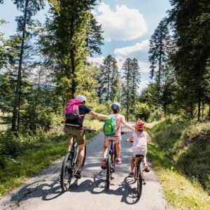
Do you like mountain biking? You can cycle on almost all forest paths. There are also designated mountain bike trails.
Since 2016 we have been a partner company of the Black Forest National Park, which is only 10 km away and can be reached by bus or bicycle.
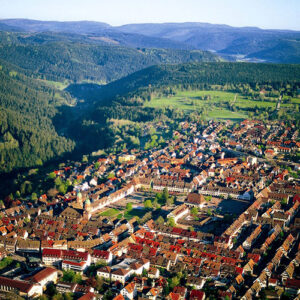
The area offers numerous opportunities for excursions, action, culture and relaxation. Freudenstadt itself has the largest market place in Germany. Freudenstadt is 3.5 km away and can be reached by bus, car, bicycle or walking.
Hikings directly from the campsite
All hikes start directly from the Langenwald campsite. Of course there are many more hiking possibilities. We recommend that you take a look at the tours in >>Outdooractive<< or >>Komoot<<. There you will find the tours below with an exact altitude profile, as well as many other hikes in our beautiful homeland.
Cycling
Almost all hiking trails can also be travelled by bicycle. Special paved cycle paths for racing bikes are, for example, the Murgtalradweg and the Kinzitalradweg. Both cycle paths can also be reached from the campsite via forest paths or the road. Many cycling tour suggestions are again available via >>Outdooractive<< and >>Komoot<< .
The Murgtalradweg leads from Baierbronn to Raststatt along the Murg. As the cycle path is always close to the railway stops, you can take the S-Bahn back to Freudenstadt at any time.
The Kinzitalradweg runs from Freudenstaft to Offenburg. It offers insights into the beautiful Black Forest villages of Schiltach, Wolfach and others.
The train stops are always in the immediate vicinity, so you can take the S-Bahn back to Freudenstadt at any time.
Enjoy nature in the National Park Schwarzwald and the National Park Region
Our unique landscape provides a retreat for many people and animals. It is everyone’s task to preserve this nature sustainably. Since 2014, the Black Forest National Park has been the only national park in Baden-Württemberg. Its motto is “Let nature be nature”. The aim is to keep human intervention as low as possible, depending on the zone.
- 20 Min
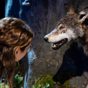
The National Park Centre at Ruhestein offers a small exhibition on the history and animals of our region. Furthermore, many guided tours are offered. The National Park Centre offers a good starting point for hikes in the middle of the Black Forest National Park to experience this distinctive nature up close.
- 15 Min
After the storm Lothar in 1999, the appearance of our region changed. The Lothar Trail offers the opportunity to see how nature regenerates itself. It takes about 20 minutes and with its footbridges, bridges and viewing platform is not only a highlight for kids.
Wasserfälle
- 20 Min
The All Saints Waterfalls are one of the most beautiful sights in our region. You can walk along the waterfalls. They are not convincing because of their size, but because of the idyllic charm that surrounds you. At the end/beginning is the ruin of an old monastery.
Mummelsee
- 40 Min
The legendary Mummelsee is located directly on the Black Forest High Road. On a small path you can walk up to the Hornisgrinde in about 30 minutes. This is the second highest elevation in the Black Forest after the Feldberg and thus offers an unmistakable landscape. The high moor is criss-crossed by footbridges on which you can walk. There is a wonderful view over the Rhine valley to the Vosges mountains. The Grinden Hütte offers the possibility of a stop for refreshments.
Weitere Ausflugsziele im Nationalpark & Umgebung
- Heimatpfad & Ellbachseeblick
- Buchkopfturm
- Lotharpfad (900 m)
- Spechtpfad (1,2 Km)
- Märchenschatzsuche Bad Peterstal (1 Km)
- Burgbachwasserfall
- Galswaldsee
- 10 min
- 25 min
- 25 min
- 20 min
- 20 min
- 20 min
- 20 min
- 30 min
- Silbersee
- Karlsruhe Grat
- Mummelsee & Hornisgrinde
- Schwarzenbachtalsperre
- Gaishöll-Wasserfall
- Luchs-und Wildnispfad (3,5-4,5 Km)
- Battert Baden-Baden
- Geroldsauer Wasserfälle
- 20 min
- 20 min
- 30 min
- 40 min
- 40 min
- 50 min
- 50 min
- 60 min
- 20 min
- 20 min
- 20 min
- 30 min
- 10 min
- 40 min
Excursion destinations in Freudenstadt & region
- 10 Min
The Panoramabad Freudenstadt is located directly in Freudenstadt, only 5 km away from the campsite. The Panoramabad has something to offer for everyone. Besides the slides, a wellness and sauna area, it has an outdoor pool and an outdoor swimming pool.
- 5 Min
The market square in Freudenstadt is the largest market square in Germany and is only 4 km away. It delights with its fountains and arcades. Especially in the summertime, it offers space for events such as the town festival.
- 40 Min
With its beautiful view over the Black Forest and its proximity to the tree tops, the treetop path is an excursion destination for young and old. It can be reached with the Sommerbergbahn or on foot. Directly nearby is the “Wildline”. A suspension bridge 380 m long and an adventure playground for children.
- 40 Min
Experience how people in the Black Forest used to live. The Black Forest Open-Air Museum Vogtsbauernhof offers you the opportunity to gain an insight into the way of life of the Black Forest people. Guided tours and workshops make a visit to the museum an experience.
Weitere Ausflugsziele in Freudenstadt & Umgebung
- 8 min
- 10 min
- 10 min
- 10 min
- 20 min
- 20 min
- 20 min
- 20 min
- 20 min
- 20 min
- 20 min
- 40 min
- 40 min
- 40 min
- 40 min
- 60 min
- 80 min